|
|
Modern Day Volcanic
Hazards
The
Following Maps and Descriptions Are For a Class Project
and Are in No Way Official, Professional or Conclusive
To draw a hazards map for Easter Island may seem a
little silly as there is no indication that it has been
volcanically active at any point during its inhabitation
by humans. Efforts at dating activity indicate,
however, that activity originating from Terevaka and its
parasitic vents in the
island’s north could have taken
place as recently as 2,000 years ago.12 As volcanologists in the USGS typically determine whether a
volcano is a threat based upon whether it was active
during the Holocene period (the past 10,000 years),
Terevaka can still be considered a potentially active
threat to the island (older Poike and Rano Kau are too
old to be considered threats on this scale).14
With no written accounts or observations of activity at
Easter Island one must turn to the geological record of
the island and observations of the terrain to estimate
what sort of threats activity could pose. An island hot
spot like Hawaii, Easter Island’s activity would likely
be characterized by low viscosity, effusive eruptions;
the kind that are more dangerous to property than people
(people can typically ‘outrun’ a slow moving lava
flow). Terevaka, in fact, is credited with tying the
three major volcanic features of modern day Easter
Island together with such lava flows.10,
pg. 218
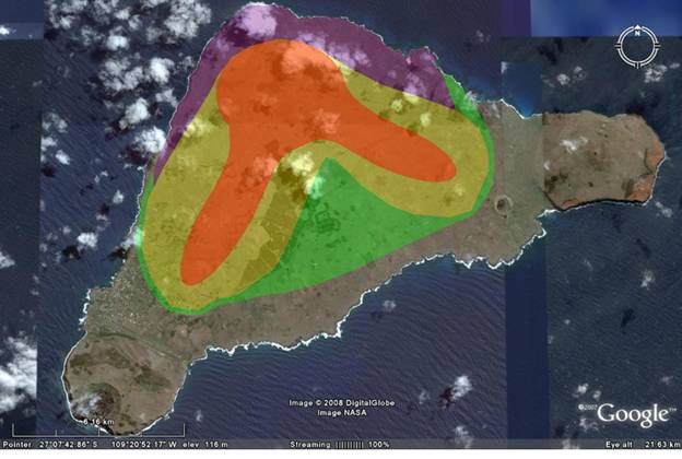
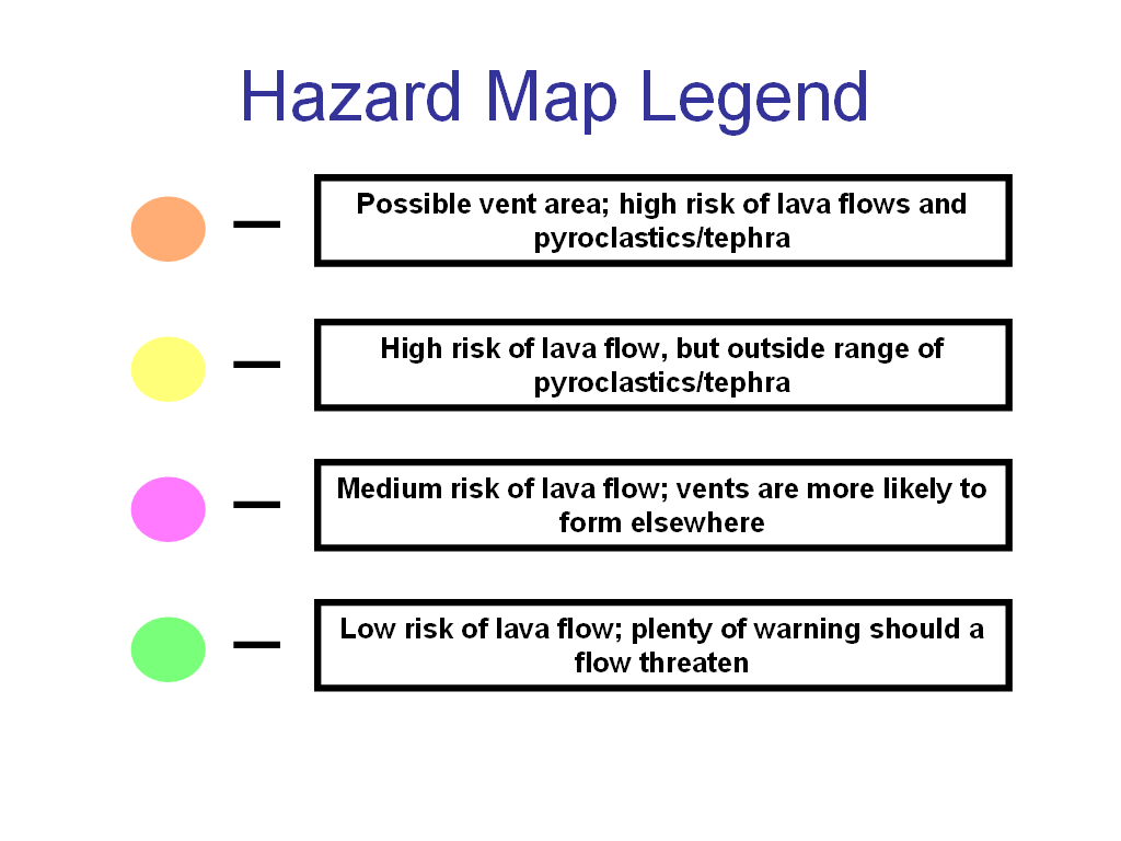
On this map the highest threat of lava flows is
represented by the red and yellow areas. They are
arranged in this two-winged fashion because the features
of the island indicate that there are two prominent
fissures extending from the main vent at the summit of
Terevaka. Along these fissures are located the majority
of Terevaka’s parasitic vents.15
The red indicates a threat in addition to lava flows
unique to the areas in the immediate vicinity of the vents. Because there are
formations around the island such as Rano Raruku which
are made of such materials as tuff and even rhyolite, there
is clearly potential for an eruption to have enough
explosiveness to throw tephra a short distance.
Baker writes that such tephra likely played a role
in the formation of Terevaka’s main summit.12
Red areas are those areas that one is most likely to
find vents with the threat of such projectiles.
The purple area indicates a slightly lower threat of
lava flow than red and yellow. Though the purple area
is located directly on the northern flank of the main
summit, I designated it a lower threat because activity
is likely to be focused on the two fissures rather than
the main summit. Because Terevaka has grown so tall (in
comparison to the rest of the island), rising magma is
likely to find an easier path out of the ground via the
fissures than it would by climbing the extra distance to
Terevaka’s summit.15
Finally, the green area is the lowest threat level for
lava flows. The layout of the land seems to
indicate that these areas were formed by lava flows from Terevaka
at some point, indicating that there is clearly some level of
threat. Yet these areas are far enough away from possible vents that the
likelihood of being hit by a flow is decreased, and the
time available for one to escape in the event of an
eruption considerable.
 |
|
Hanga Roa
Post Office16 |
Hanga Roa, the island’s only town/village and therefore
essentially the location of the entire population, is
partially located within the area threatened by lava
flows (though not pyroclastics/tephra). It is
visible on the SW corner of the island. The decision
must therefore be made whether it is worth investing in
a system or evacuation plan to
protect this area from potential activity. Because
an eruption is so unlikely, and because any activity
that may occur has only a small chance of
originating in the areas that may threaten Hanga Roa, it
simply is not necessary to undergo large scale
preparations. Something like a Public
Address system in town might be a worthwhile investment
as it can be utilized in other ways during the extended
periods of inactivity, but mock evacuations and
large-scale volcanic preparation projects would likely
be nothing more than fear-mongering. Easter's
isolation would also make such drills cost-prohibitive,
and the damage to a largely tourist economy would
undoubtedly be great.
Why no
evacuation plan?
|