|
|
Assessing
Risks
National Volcano Early Warning System
From PDF by John Ewert, USGS
Open-File Report 2005-1164
The United
States Geological Survey recognized that there were
potentially dangerous volcanoes in the United States and
around the world that were not being properly monitored.
Because of the gap in monitoring, they have developed
the National Volcano Early Warning System for managing
volcanic hazards in the United States. NVEWS is a
systematic assessment of many volcanic hazards and
exposure factors that can be used to calculate a threat
score for each volcano. Based on this score, volcanoes
are put into five threat groups, ranging from very low
to very high. Each threat group is associated with a
level of monitoring that the volcano should be
receiving. However, in most circumstances there is a
gap between how the volcano should be monitored and how
it is being monitored. These gaps show officials where
improvement is needed most. This is extremely important
because proper monitoring of volcanoes can provide
populations living in the surrounding areas with needed
warnings before an eruption takes place.
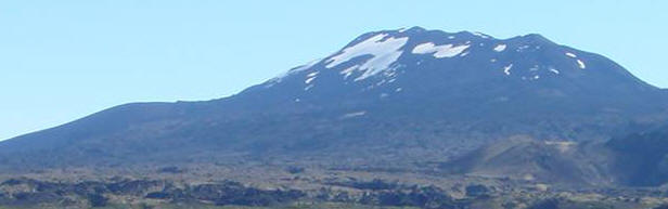
NVEWS uses both the historical background of the volcano
and the exposure of the volcano to calculate threat.
The historical hazards and exposure factors for Mt.
Hekla are calculated below.
|
Hazard and exposure factors used in threat
assessment of U.S. volcanoes for the National
Volcano Early Warning System.
See appendix text for discussion and explanation
of abbreviations. |
|
|
Hazards Factors |
|
Score |
|
Volcano type
If volcano type is cinder cone, basaltic field,
small shield, or fissure vents: Score = 0
If volcano type is stratocone, lava domes,
complex volcano, maar or caldera: Score = 1
Eruptive History
information: Smithsonian Global Volcanism
Project 26
|
1 |
|
Maximum Volcano Explosivity Index (VEI)
If maximum known VEI ≤ 2: Score = 0
If maximum known VEI = 3 or 4: Score = 1
If maximum known VEI = 5 or 6: Score = 2
If maximum known VEI ≥ 7: Score = 3
If no maximum VEI is listed by GVP and if
volcano type = 0: Score = 0
If no maximum VEI is listed by GVP but volcano
type = 1: Score = 1
If no known Holocene eruptions and the volcano
is not a silicic caldera system: Score =
0
Eruptive History
information: Smithsonian Global Volcanism
Project 26
|
1 |
|
Explosive activity
If explosive activity (VEI ≥ 3) within the last
500 years: Score = 1
Eruptive History
information: Smithsonian Global Volcanism
Project 26
|
1 |
|
Major
explosive activity
If major explosive activity (VEI ≥ 4) within
last 5000 years: Score = 1
Eruptive History
information: Smithsonian Global Volcanism
Project 26
|
1 |
|
Eruption recurrence
If eruption interval is 1-99 years: Score = 4
If eruption interval is 100 – 1,000 years: Score
= 3
If eruption interval is 1,000 to several
thousand years: Score =2
If eruption interval is 5,000-10,000 years, or
if no Holocene eruptions but it is a
large-volume restless silicic system that has
erupted in the last 100,000 years: Score = 1
If no known Holocene eruption: Score = 0
Eruptive History
information: Smithsonian Global Volcanism
Project 26
|
4 |
|
Holocene pyroclastic flows?
If yes: Score = 1
Eruptive History
information: Smithsonian Global Volcanism
Project 26
|
1 |
|
Holocene lava flows?
If Holocene lava flows have traveled beyond the
immediate eruption site or flanks and reached
populated areas: Score =1 14 |
1 |
|
Holocene lahars?
If Holocene lahars have traveled beyond the
flanks and reached populated areas: Score =1
|
0 |
|
Holocene tsunami(s)?
Has it produced a tsunami within the Holocene?
If yes: Score = 1
Eruptive History
information: Smithsonian Global Volcanism
Project 26
|
1 |
|
Hydrothermal explosion potential?
If the volcano has had Holocene phreatic
explosive activity, and/or the volcano has
thermal features that are extensive enough to
pose a potential for explosive activity: Score
=1
Eruptive History
information: Smithsonian Global Volcanism
Project 26
|
1 |
|
Sector collapse potential?
If the volcano has produced a sector collapse in
Quaternary-Holocene time and has re-built
its edifice, or, has high relief, steep
flanks and demonstrated or inferred alteration:
Score = 1
Eruptive History
information: Smithsonian Global Volcanism
Project 26
|
0 |
|
Primary lahar source?
If volcano has a source of permanent water/ice
on edifice, water volume > 106
m3:
Score = 1
Eruptive History
information: Smithsonian Global Volcanism
Project 26
|
1 |
Historical Unrest Factors
|
Score
|
Observed seismic unrest
Since the last eruption, in the absence of eruptive activity,
within 20 km of the volcanic edifice? If yes:
Score = 1
30 |
1
|
Observed ground deformation
Since the last eruption, in the absence of eruptive activity,
inflation or other evidence of magma injection?
If yes: Score = 1
32 |
1
|
Observed fumarolic or magmatic degassing
Since the last eruption, in the absence of eruptive activity,
either heat source or magmatic gases? If yes:
Score = 1 |
0
|
Total of Hazard Factors
|
15
|
Exposure Factors
|
|
|
Log10
of Volcano Population Index (VPI)
at 30 km
Calculated with LandScan population database. Visitor statistics
for volcanoes in National Parks and other
destination recreation areas are added to the
VPI factor where available.
35 |
3.75 |
|
Log10
of approximate population
downstream or downslope
Population outside the 30 km VPI circle included within the
extent of Holocene flow deposits or reasonable
inundation modeling. This factor to be used only
with volcanoes that have a primary lahar hazard
(e.g. Cascade stratovolcanoes) or significant
lava flow hazard (e.g. Mauna Loa).
35 |
0 |
|
Eruptive History
information: Smithsonian Global Volcanism
Project 26
|
|
|
Historical evacuations?
If yes, and a permanent population is still present: Score = 1
Eruptive History
information: Smithsonian Global Volcanism
Project 26
|
1 |
Local aviation exposure
If any type volcano is within 50 km of a jet-service airport,
score = 1; if a Type 1 volcano is within
300 km of a jet-service airport, score = 1; if a
Type 1 volcano is within 300 km of a
major international airport, score = 2; if none
of these criteria are met, score = 0.
34 |
2
|
Regional aviation exposure
This score is based on the log10
of approximate daily passenger
traffic in each region. At present, in the U.S.,
this score ranges from 4 to 5.15. The regional
risk code is applied only to type 1
volcanoes and those type 0 volcanoes that
have produced explosive eruptions.
34 |
3.8
|
Power infrastructure
Is there power infrastructure (e.g., power
generation/transmission/distribution for
electricity, oil, or gas) within flowage hazard
zones, or in an area frequently downwind of the
volcano and close enough to considered at some
risk? If yes, score =1 |
0
|
Transportation infrastructure
Is there transportation infrastructure (e.g., port facilities,
rail lines, major roads) within flowage hazard
zones, or in an area frequently downwind of the
volcano and close enough to considered at some
risk? If yes, score = 1
36 |
1
|
Major development or sensitive areas
Are there major developments or sensitive areas threatened (e.g.,
National Park facilities, flood control
projects, government facilities, developed
tourist/recreation facilities, manufacturing or
other significant economic activity)? If yes,
score =1
35 |
0
|
Volcano is a significant part of a populated
island
Holocene volcanic deposits cover >25% of land mass. If yes, score
= 1 1312 |
1
|
Total of Exposure Factors
|
13.55
|
Sum of all hazard factors x Sum of all exposure factors =
Relative Threat Ranking
|
203.25
|
 36 36
What does this figure mean?
The figure calculated above describes the very
high risk threat level associated with Mt. Hekla. A
score of 203.25 fits Hekla into a group of volcanoes
having VERY HIGH overall threat scores (324 to 123
points). Volcanoes in this category should be very
heavily monitored because of their increased threat.
This number and level might be slightly misleading in
that many of the events counted when calculating this
number have only happened once or twice. Because Hekla
has been so well documented since the 1104 eruption,
there are records of these hazards occurring and
therefore they must be counted.
37
What is the current level of monitoring at Mt. Hekla?
Because the monitoring level is highly based on the
number of seismic stations, and I could only find nine
seismic stations, the monitoring level for Hekla is at
three. This is slightly misleading because seismic
stations are not as important for Hekla because the
volcano gives very little seismic warning before
eruptions. However because of the seismic stations
Hekla does have, the GPS deformation monitoring,
borehole strain monitoring and observations, Hekla is
covered very well. According to the USGS, level three
is basic real time monitoring that provides, “the
ability to detect and track pre-eruptive and eruptive
changes in real-time, with a basic understanding of what
is occurring” (NVEWS).
37
Personally, I would Hekla more of a level four
as far as monitoring goes. A level four includes more
seismic stations consider(which are not really needed),
digital stations, borehole instruments, deformation
monitoring, gas monitoring, hydrologic studies, infrared
images and Doppler radar coverage. Volcanologists
studying Hekla use many of these monitoring devices to
watch the volcano for any activity.
Should any changes be made to mitigate risk at Hekla?
Hekla is a very well monitored volcano in an
area with very experienced Volcanologists. The area
around the volcano is not very populated and there is an
extensive historical record for volcanologists and
officials to consider. As long as the current
monitoring continues, I would not change anything.
|