|
Hazards
Creating a hazard map is a difficult process that takes
into account the eruptive history of the volcano and the
geological features surrounding the volcano.
Creating a map that shows lava flows is complicated by
the fact that Hekla does not have one main vent, but
opens along a long fissure. Lava can flow from any
point along this fissure and it is hard to predict where
that point will be. With Hekla, there are also radial
and regional fissures that open up and erupt lava. This
makes determining where the lava will flow very
difficult.
However, by looking at maps that show the historical
flows and by looking at the shape of the volcano, I have
developed two hazard maps (only for a school project,
these are NOT
real hazard maps). The maps show the
different sizes of eruptions that have taken place at
Hekla and the different types. Below are hazard maps
for a small scale eruption, with a shorter lava flow and
smaller amounts of erupted tephra, and maps depicting
hazards for larger eruptions with more erupted
material. I decided to split these maps up because
Hekla has been very active in the modern era, but erupts
very differently at different times. Because of Hekla’s
location, sometimes the magma has a chance to cool and
erupts very violently, other times there is an effusive
eruption with very little ash fall out. Examples of
these different styles would include comparing the
eruptions in 1104, 1693, 1766, and 1845 to an eruption
in 1980. The eruption types are drastically different.
Eruptions like the one in 1104, were very explosive
and ash went very far distances. However, the eruption
in 1980 was effusive with very little ash.
Looking at ash fall
is important because after major eruptions, people
living in areas where there was ash fall have
experienced problems with fluorine. The fluorine from
the ash gets into the ground water and is toxic to
grazing animals in the area.
1104 Eruption
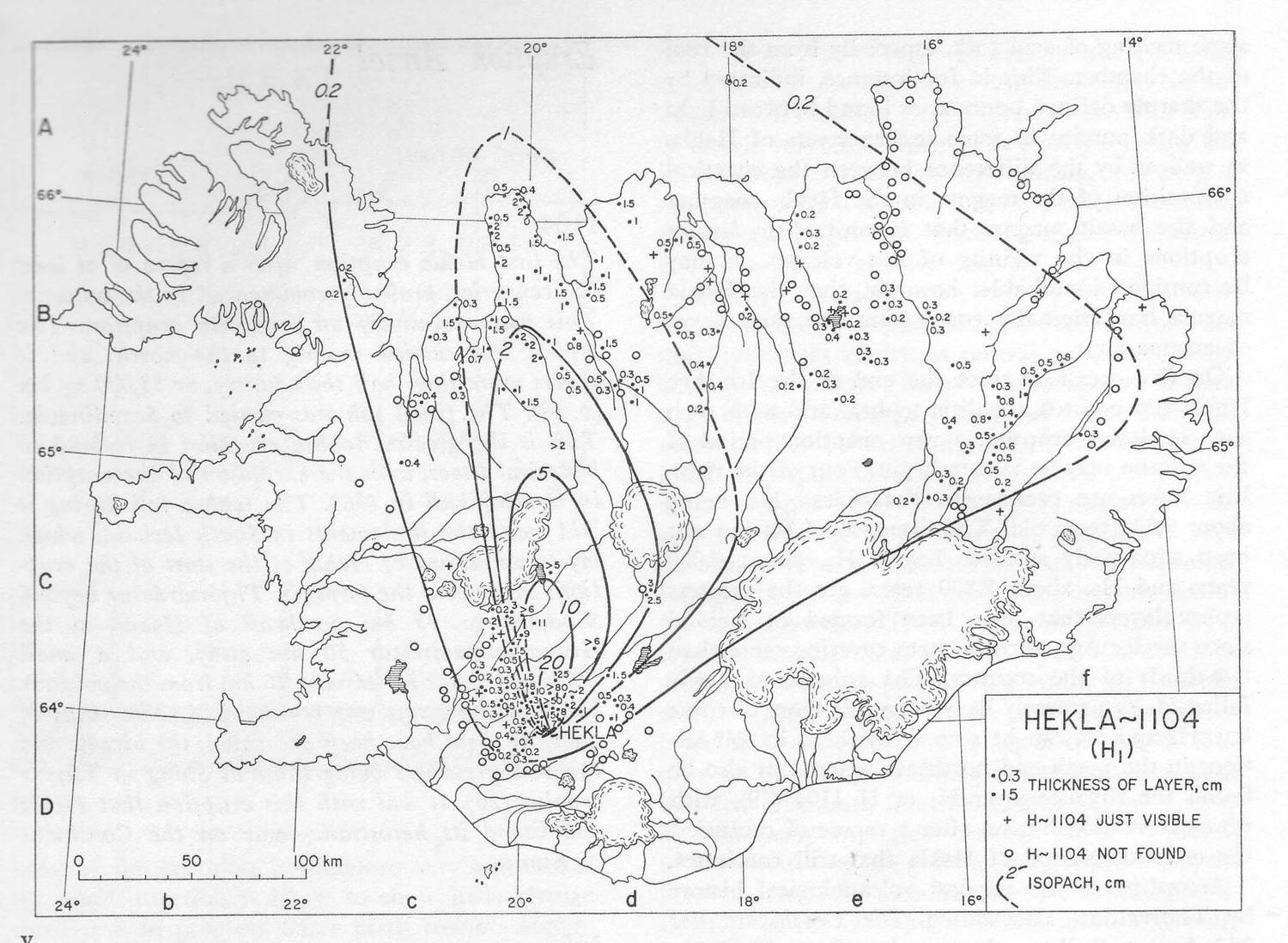 12 12
This map shows the tephra distribution
from the 1104 AD eruption of Mt. Hekla.
1980 Eruption13
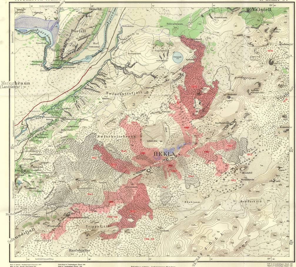
Historical Lava Flows14
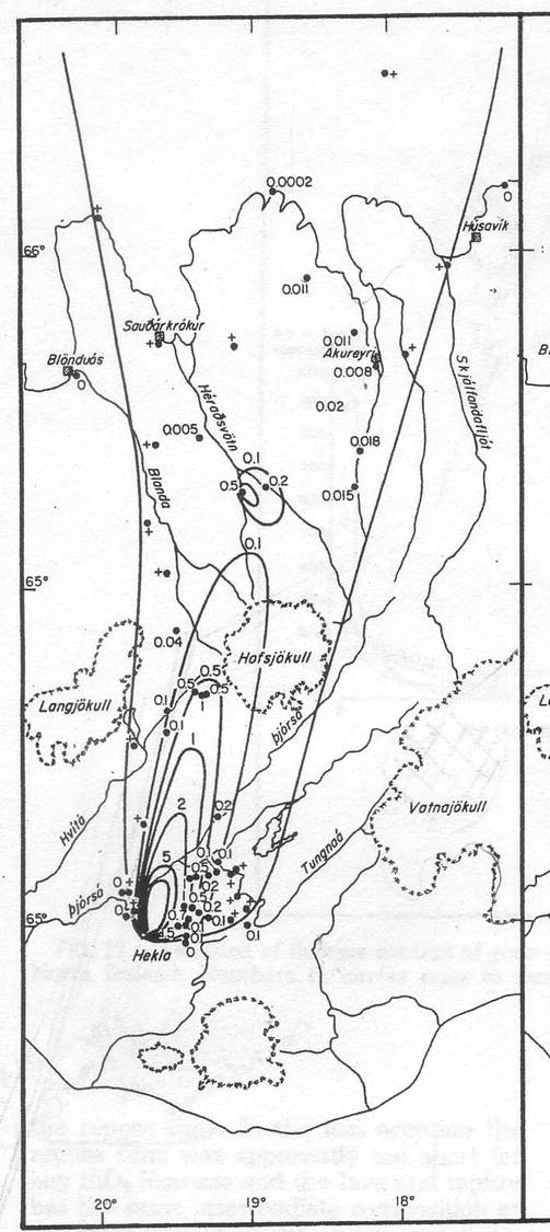
This map shows the tephra distribution
from the 1980 eruption of Mt. Hekla.
This Map shows the historical lava flows from eruptions
of Mt. Hekla.
My Hazard Maps
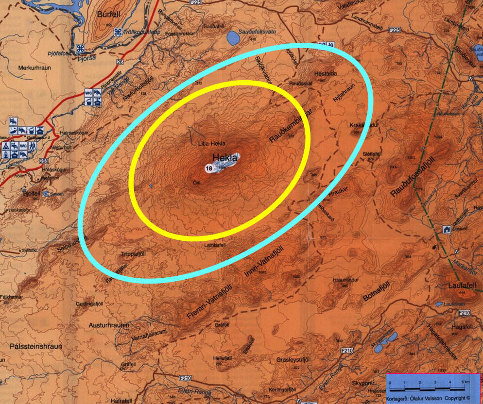
Lava Hazards
This map was created
for a school project, it is not an official hazard map.
For this map, I looked at the historical flows and saw
that largest eruptions never went more than 10 km away
from any point along the fissure, and even less distance
off the sides of the fissure. The smaller eruptions
never went more than 5 km away from any point along the
fissure. The blue line on this map represents the
hazard area for lava flow in a large eruption and the
yellow line represents the hazard area for lava flow
during a small eruption. Normally, hazard areas for
lava flows follow the topographic features of an area.
Because it is very hard to predict where along the
fissure lava will flow during an eruption, I decided to
circle the entire area. I do not think this is very
problematic for property owners because the area is
pretty uninhabited.
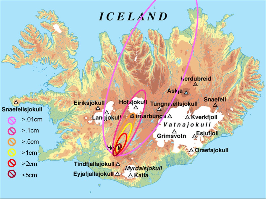
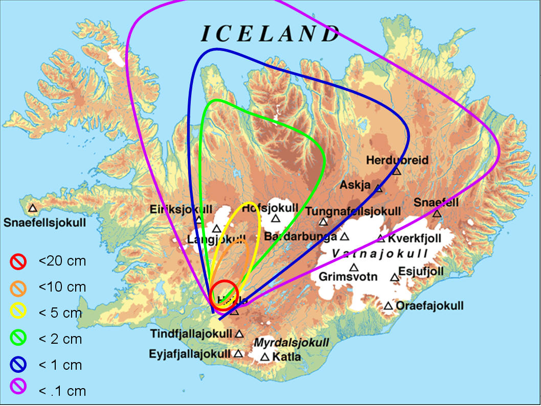
Tephra
Hazards
These maps were
created for a school project, they are not official
hazard maps.
For these maps, I again looked at
historical maps. I drew in isopach lines that show the
minimum depth of ash fall in any given area. For
example, in the red circle, ash fall will be greater
than twenty centimeters. In the area encompassed by the
green circle, ash fall will be at least 2cm. I drew the
circles tilted towards the north/north east because that
is the prevailing wind direction in this area. However,
wind direction can change with a passing storm or front,
and turn the dispersion area in a different direction.
The maps were split up based on eruption size because of
the obvious difference in scale. I think that the
tephra hazard maps are more important to the public
because the winds can blow the ash into populated areas
and the fluorine in the ash can poison livestock.
Smaller Eruptions15
Bigger Eruptions15
What kind of eruption will there be?
Hekla is a unique volcano because its eruption style
changes so drastically. The way Hekla erupts seems to
correlate with the length of the repose period. When
Hekla erupts frequently, the eruption tends to be an
effusive one, with little tephra dispersal. When there
is a long repose period, Hekla tends to erupt more
violently. For example, the eruptive history shows
that before the large eruption in 1845 there was almost
80 years of quiet. This can be contrasted with the
eruption smaller, effusive eruption in 2000 that had
only nine years of quiet preceding it. The pattern
right now seems to show that Hekla erupts about every
ten years. The eruptions, like the one in 2000, tend to
be small and effusive and do not last for very long. 29,
17
|