|
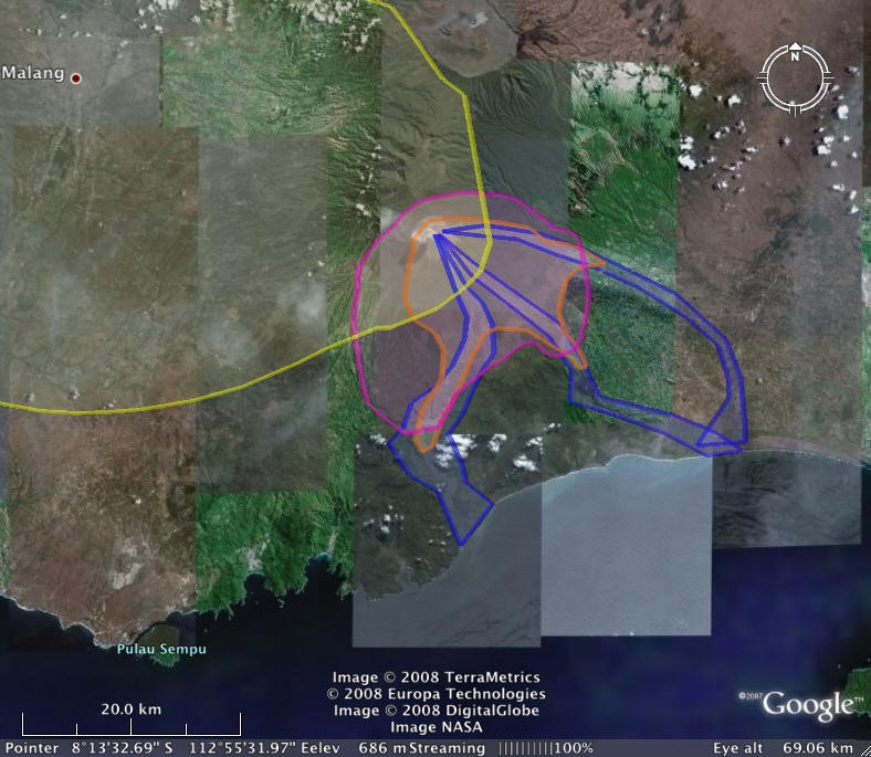
Semeru
Hazard Map
(This is not an
official hazard map, it is my interpretation
of the hazards for a
class)

Blue
zones are areas
where lahars are extremely likely to occur.
Purple
zones are areas
where lahars may occur but are less of a threat than the
blue zones
Orange
zones are areas
where pyroclastic flows and surges are a threat.
Yellow
zones are areas
likely to be covered by ash fall.
The hazards on this map
were determined using information from the Global
Volcanism Project's reports on the volcanoes activity and
from the topography of the region as determined by
Google Earth.1 The major lahar danger zones were
based off of the preexisting lahar flows that are
visible on the map. The less dangerous lahar zones
were determined based on the topography of the volcano
(visible through Google Earth). The pyroclastic
flow danger zones were drawn with the expectation that
the flows would be likely to follow the same large
valleys that the lahars follow. The possibility of pyroclastic flows was determined from the Smithonian's
records of previous pyroclastic flows at Semeru.
The ash fall zones are located to the west of the
volcano because the prevailing winds in the region blow
from east to west.
Risks:
Lahars: The
largest risk at Semeru is definitely lahars.
Despite not being covered by snow, like most volcanoes
that generate lahars, it has regular lahars, many of
which are large. However, the lahars that effect
Semeru are unlike most lahars because they are
predictable. Almost all the lahars at Semeru are
secondary lahars and are triggered by rain fall. There
are frequent and more destructive lahars in the rainy
season and few in the dry season.3 The
reoccurrence of lahars is primarily do to two things.
One is the fact that Semeru erupts everyday and deposits
lots of loose ash on the upper flanks of the volcano.
This is turned into lahars by the extreme amount of
rainfall that Semeru receives, which is approximately an
amazing 38 meters a year! Most of this rain falls
during the months of November to April.4
The risks surrounding lahars can me limited in a number
of ways. First, people should stop living in the
lahar valleys. If they can be seen on satellite
there probably pretty obvious when your standing on
them. Second, the government should inform the
people that when it is the rainy season because lahar
danger will be high and they are somewhat predictable.
Finally, some monitoring instruments should be set up at
points along the lahar valleys, so that some warning
might be possible.
Ash Fall:
Ash fall is not usually a major threat because the ash
from the regular eruptions rarely reaches beyond the
slopes of the volcano. In the case of a large eruption
ash will probably reach the cities and roof collapse
becomes a threat. In that situation, my best
advice is get on your roof and start shoveling the ash
off. It also may be prudent to wear something over
your face to prevent ash inhalation.
Other Risks:
There are other risks at Semeru, but most are less of a
concern. Pyroclastic flows almost never reach beyond the
slopes, so simply stay off the slopes if you don't want
to encounter one. Same rule applies for lava bombs
and other dangerous projectile or lava products.
Planes should simply avoid flying over the vent in order
to avoid ash columns. Almost all the other hazards
besides ash and lahars can be avoided by not taking the
National Park tour.
|