|
Mauna Loa By Julie Wallan |
|
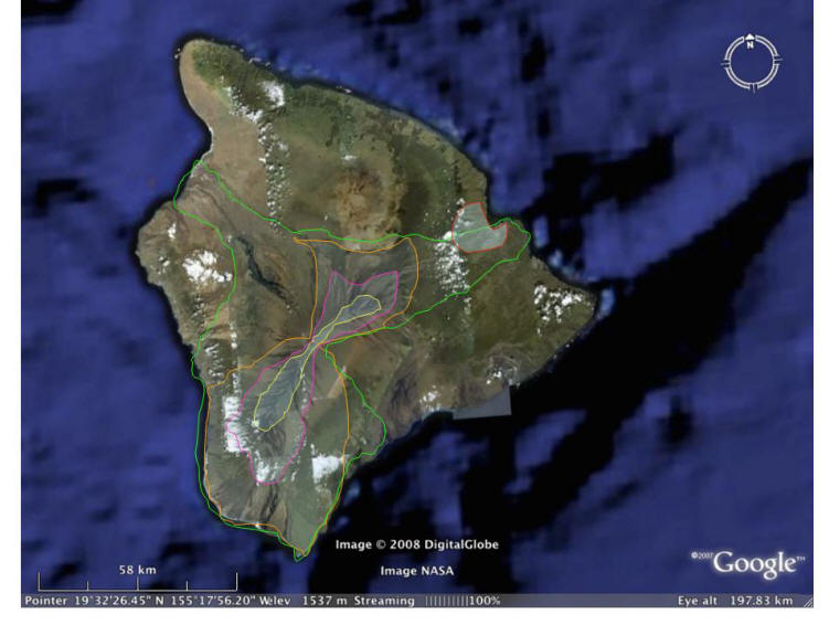
Hazards WARNING: THIS IS NOT AN OFFICIAL HAZARD MAP, BUT IS MY INTERPRETATION BASED ON RESEARCH
Hazard Map Key After researching the eruptive history of Mauna Loa and studying the hazard maps drawn up by Hawaiian volcanologists, I have created my own hazard map for Mauna Loa. (The RED section is the general region of the largest city on the Big Island, Hilo)The main hazards at Mauna Loa consist of lava flows, often in the form of a'a. The YELLOW section shows the area where magma is most likely to burst through the surface. Practically none of the population is in danger in this zone. All past eruptions after the formation of the basic structure of the island have taken place along this ridge. The PINK section shows the boundaries of a substantial but relatively average-sized flow. Again, an insignificant amount of people are in danger in this zone. As a larger volume of lava is produced, the flows go down either side of the peak, but not near any big towns. Development on this area should be prohibited until Mauna Loa shows a significant turning point in the size of its eruptions, which would indicate a period of decline in activity as it moves off the hot spot. The ORANGE section shows what a substantial eruption with a large volume of lava and fairly quick effusion rate has the ability to do. These eruptions occur less often, and have the ability to reach insignificant numbers of people in the area because the flows have never been lead in the direction of major towns on the island. It should be advised that no development occurs in this section. However, the expanding economy and population could override this warning. As long as the Observatory is prepares the population with a method of action in case of an eruption, everyone will be safe in this zone. The nature of Hawaiian volcanism and the high level of monitoring provides ample warning for eminent eruptions. The last section, GREEN shows what could happen in the event of a major eruption, which would be a very least-likely case of hazards in the event of an imminent eruption because they are a rare occurrence. A very large eruption could have the potential to damage significant amount of property, but the main concern would be if the lava reached the North East side of the island, where much of the population resides. An effort should be made through intervention on the side of government to keep the population very aware of what the area is capable of. Warnings should be widely publicized against the use of this land, and obstacles should be put in place like increased cost of land instead of decreased (because of the hazards) to discourage new development. But nothing is certain, and as long as people are warned, they are in no real danger because of the efficiency of their monitoring system. An eruption of this magnitude is unlikely based on historical events; the last time a lava flow reached the area of Hilo was in 1881.
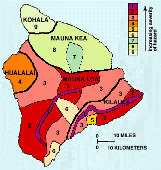
An example of a hazard map drawn for the entire island of Hawai'i. 1 is the zone with the highest level of hazards, 9 the least.
Population and Economy
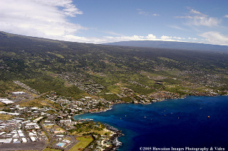
Mauna Loa in the background of a developed area by the ocean.
The population on the Big Island is distributed in such a way so that the most concentrated areas happen to be almost guaranteed safety from lava flows.25 & 26 However, the population is growing and spreading out, which is problematic when the frequency of eruptions is taken into account: there have been 33 since 1843.6 Furthermore, the United States Census data shows a 240% increase in the Hawaiian population from 1960 to 2000.6 Some areas of the island have increased in population in dangerous zones such as Hawaiian Ocean View Estates, located downhill from the Southwest rift zone.6 Topography of the region is important, but scientists have also observed other important factors to take in to account when assessing the hazards of Mauna Loa: that Hilo is more in danger of pahoehoe lava tubes from high effusion rates because the more common a`a flows generally cool too fast to pose a threat.6 Scientists determined more knowledge of the lava channel lengths of Hawaiian flows by using a model called FLOWGO, which uses the known vent locations to simulate flows.
Other factors of volcanism like earthquakes have the potential to disrupt, but major destruction is somewhat infrequent. Despite the fact that erupting volcanoes normally discourage the population from remaining because of the risks and hazards involved, leading to declining tourism and economies, Hawaiian volcanoes almost excite the economy. Their effusive nature makes them fairly safe, and every tourist on the island wants to go see a lava flow. Indeed, much of the tourism on the Big Island revolves around their majestic volcanoes.
Minimizing Risk
Mauna Loa is a very highly monitored volcano and poses little threat to the population because of its effusive nature. The main concern as of now is the selling of property on old flows and in hazard zones. I believe that the Geological Institute should advise those realtors and prospective homeowners of the dangers involved, and possibly attempt to prevent the buying and selling of property in lava hazard zones. As long as the rapidly growing population is informed, and attempts are made to divert building on lava flow hazard areas, property damage risk will be minimized. For all written records, no deaths have been recorded at Mauna Loa, and I believe that the Observatory has ample monitoring systems in place to warm the population should anyone or anything be in danger.
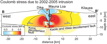
Coulomb failure changes in stress. The image shows the outward seaward movement and inward dip of the island in relation to Mauna Loa.
However, improvements can always be made in order to better prepare the population in the account of an eruption, and many scientists have made innovative observations about the mechanisms involved with Mauna Loa. Recent studies have been made that could potentially predict where the next flow will go, which vent it will erupt from, and when it will occur. Scientists have found evidence using a complex form of radar data of inflation in a body of magma resembling a dike in the southwest rift zone of Mauna Loa from 2002 to 2005. They have discovered this because the accumulation was observed in an unclamped (by other dikes and earthquakes) region of the rift zone, where the factor of stress transfer plays a prominent role in controlling magma accumulation below the surface. Comparing the results from a model magma chamber and historical eruption data led to the conclusion that about 80% of rising magma penetrates the deep and intermediate levels of the rift zone, a different area than the alternate magma pooling at a shallower depth. Based off of their experiments and eruption patterns in Mauna Loa's history, this group of scientists predicted that the Southwest Rift Zone is the most probable location for a dike of new magma accumulation and eruption. Ultimately, they produced a new model for the magmatic system of the volcano in which most of the magma remains in the deep areas of the rift zone, causing the stress field to alter and allow dike formation in shallower areas along faults. New theories and predictions like these can assist the drawing of hazard maps for the most accurate detail. Understanding the mechanisms behind Mauna Loa and its past history are key elements to determining the nature of future eruptions.
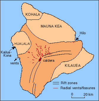
A simple diagram of Mauna Loa's main vents, the most active being the Moku`aweoweo caldera and the Northeast and Southwest Rift Zones. The red lines show the 33 official vents identified thus far.
For more information about the Hazards of Mauna Loa visit: http://hvo.wr.usgs.gov/maunaloa/hazards/main.html
|
|