|
Hazard
Maps
The following maps are my amateur interpretation for a class of the risk that pyroclastic flows and surges, ash fall and lahars pose to the area surrounding Cotopaxi. They were
determined using the topographical information of Google Earth,10 as well as the eruptive history of Cotopaxi from the Smithsonian Institutional Global Volcanism Program.2
The hazard zones were based on the known history of Cotopaxi, the surrounding topography, and general knowledge of the nature, power, size and length of pyroclastic flows, lahars and
ash fall, as well as information from the Instituto Geofisico of Quito.11
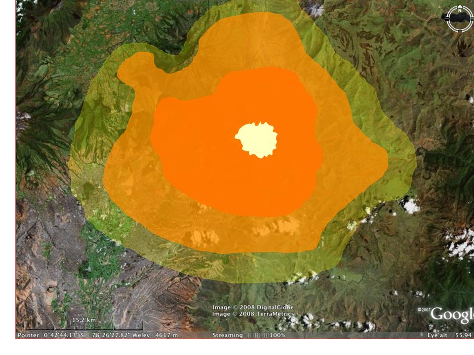
Pyroclastic Flows and Surges
Yellow Area: this area is of minimal threat to pyroclastic flows and surges. People living in this area should be informed of the dangers of pyroclastic flows and surges,
as well as aware of the activity of the volcano, but only a very large eruption would put them in immediate danger of this hazard.
Light Orange Area: this area is in moderate danger of pyroclastic flows and surges affecting it during a moderate to large eruption with a sustained ash column. People living in these areas
should be well aware of the dangers that pyroclastic flows and surges pose to crops, shelter, animals and people. They should also be aware of the activity of the volcano, particularly if it
is showing signs of unrest. They should be warned if the volcano begins to act up and evacuated if it shows signs of an imminent eruption.
Dark Orange Area: people living in this are, or anyone visiting the volcano and entering this area, should be made well aware of the dangers of pyroclastic flows and surges as well as acutely
aware of the activity of the volcano. They should know that they are in an area of very high risk, and should an eruption be predicted or expected at all, people in this area should be informed and
evacuated first. If there is any irregular or suggestive activity in Cotopaxi, these people should be informed first and be reminded of the destructive force of ash flows.
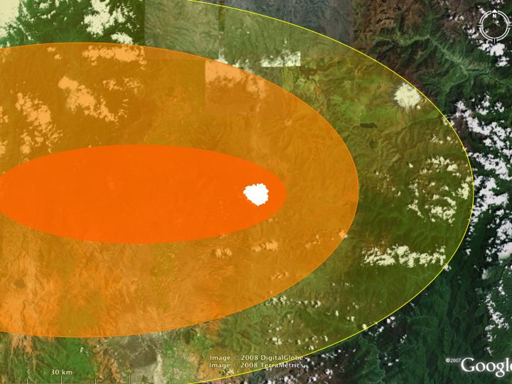
Uncovered area: this area is least likely to be covered by a large amount of ash in the event of an ash-producing eruption, even a large one. However, a small
amount of ash fall is likely to occur in this area, the amount varying depending on the size and extent of the ash column. Also, it should be noted that these hazard
zones are based on the prevailing wind direction of the area,12 and should an extraordinary wind current pick up, the most prominent ash fall area could change.
Yellow Area: this area is likely to experience a small to moderate amount of ash fall (15-50 cm),* again varying based on the height of the eruption column, amount of material
ejected and wind direction and speed. Any people living in this area should know how to deal with ash fall, as well as be aware that ash fall is much more destructive and
dangerous than one would think.
Light Orange Area: this are is in danger of experiencing moderate to heavy ash fall during and after an eruption (50-200 cm of ash).* People in this are should be made aware of the
dangers of ash fall and ballistics, which could easily fall in this area in a strong enough eruption. Also, it should be noted that a change in wind direction could easily
change any party of this zone to red zone.
Dark Orange Area: anyone living in this area should be well prepared to deal with the dangers of heavy ash fall and ballistics.
They should be ready to evacuate in the event of a moderate to large eruption. This area is likely to be covered in up to or beyond 400 cm of ash.*
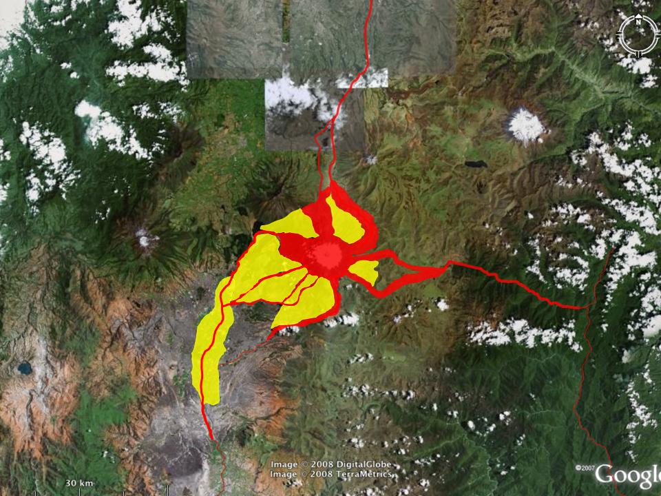
Yellow Area: these areas is not likely to be channels of a major lahars, but they are at risk of being covered by lahars or be part of an initiation of a lahar,
since they are near the vent and could be covered in ash or snow. People living in these areas should be recipients of any lahar warnings by monitors
of the volcano. They should also be aware of the activity of the volcano in order to know when lahars might be at risk of occurring.
Red Area: these are the primary channels that lahars generated on any part of the volcano would travel. They follow rivers to the South, North and East. The thicker
the line, the more likely and stronger a lahar is likely to be when flowing through that area. The famous lahars of 1877 travelled north-northwest, to the east, and to the south,
following these channels.13 The one travelling north went 326 km before ending in the Pacific Ocean, while the one heading east travelled over 130 km to the Amazon basin.13
*Based on isopach map from P.11 of Minard Hall, Patricia Mothes's essay18
|