|
|
the
great lahars of 1877
In January of 1877, and
eruption started on Cotopaxi that would initiate one of
the longest-travelling mudflows in history.18 Although
there was little known about the volcano at the time, it
had been active and having frequent eruptions since
about 1844.2 This eruption, however, was
substantially larger with a VEI of 4, rather than the
consistent 2-3 VEI eruptions that Cotopaxi had been
experiencing for over a century.2 The mountain's snow-capped
peaks rumbled as tephra and lava were ejected from the
vent, and the heated snow mixed with ash and melted,
causing a huge mudslide that travelled up the Chillos
valley to the Pacific Ocean, down the Rio Cutuchi to the
south and the Rio Napo to the east, stopping in the
Amazonian basin.13 The longest lahar, which
reached the Pacific Ocean, travelled a total distance of
over 326 km.13
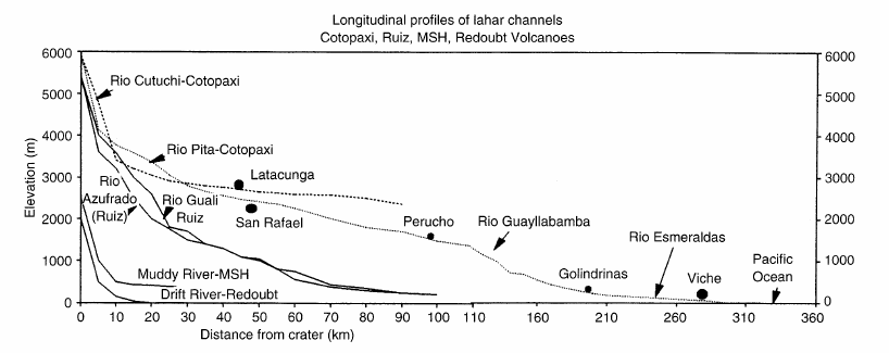
The following is a
longitudinal profile of the main river systems that
drain Cotopaxi's melted snow and channel its lahars.13
The Muddy River and Drift River are from Mount St. Helens
and the Redoubt volcanoes, respectively, to show
comparison.13 The dots indicate major towns
and cities that the river systems pass through.
 13 13
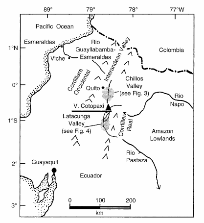
This is a map of Cotopaxi
Volcano and the surrounding valleys and mountains.13
The black lines indicate the directions in which the
1877 lahars travelled.13 Note the distance
the north-flowing lahar had to travel to reach the
ocean.
 13 13
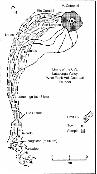
Below is an outline of
the major drainage streams of Cotopaxi from the
southwest, as well as the direction in which the
Latacunga Valley lahar travelled.13 Note all
of the towns affected, including Latacunga, which has a
current population of 143, 979.14
 13 13
The exceptional events of
the 1877 eruption were by no means expected. However, if
the key to the future is indeed in the past, then the
threat of such an event occurring again is indeed
something to consider when assessing this volcano's
danger. Towns such as Latacunga are not well-equipped or
prepared to deal with the devastation that a massive
lahar could bring. This student knows first-hand, having
travelled through Latacunga and seen the path that a
lahar would travel. It is for this reason that this page
was specifically created: to highlight the dangers that
lahars, among other hazards, pose to the towns and
villages that not only surround Cotopaxi but that are on
its river channels. The devastation and loss of life
that might result from a massive lahar is not to be
taken lightly.
|