|
|
Visiting a Volcano
Where is it?
Volcán de Colima is
situated approximately 125 km (75 miles) to the south of
Guadalajara, in the Mexican state of Jalisco7.

Fig. 3.1
Political map of the state of Jalisco, displaying
important geographical features.

...to be more
specific:
Colima, Mexico
Latitude: 19.514° N,
19°30'50"N
Longitude: 103.62°W,
103°37'0"W6
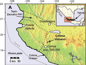
Fig. 3.2
Geographical, topographical, and tectonic
representation of location of Colima volcano.
Volcán de Colima is part of the
Trans-Mexican Volcanic Belt, or the TMVB
for short.
The TMVB is a 1000
km-long continental volcanic arc caused by the
subduction of the Cocos and Rivera plates under the
North American plate24.
This arc runs from the Gulf of California, across the
Central part of Mexico, and over to the Gulf of Mexico24.
The TMVB produces a
wide range of volcanic characteristics, from
stratovolcanoes, calderas, domes, and single-source
cones, but the composition is generally "calc-alkaline,"
and is thus responsible for Colima's classification as
an andesitic stratovolcano24.
The western portion
of the TMVB, where Colima is located, contains the
Colima Graben, the Zacoalco fault zone, and the Chapala
Graben12,
which converge to the north and east of the Jalisco
Block, where the Colima complex is situated24.

The Jalisco Block experiences a
unique combination of extensional
tectonics caused by the rifting at
the Colima Graben and compressional
tectonics at the subduction zone of
the Rivera and North American Plates12.
Fig. 5
"Location of Volcán de Colima in the
western portion of the Trans-Mexican
Volcanic Belt. Abbreviations are:
MC=Mexico City, T=Toluca,
G=Guadalajara, M=Morelia, TMVB=Trans-Mexican
Volcanic Belt, and MAT=Middle
American Trench. (B) Sketch map of
the Colima Graben showing the
location of the Cantaro, Nevado de
Colima, and Colima volcanoes"
Minus the
technical stuff:
A
more realistic and simplistic representation of the
volcano and its setting.

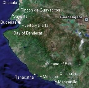
Fig.
3.3 Satellite image of Colima volcano
(Volcano of Fire) and surrounding area.
|