|
|
Hazard Map
Assessment for Volcan Villarrica and the surrounding area:


 Volcan Villarrica has produced a wide array of
eruption styles, from Hawaiian to Plinian, making it very hard to
create a comprehensive, and yet practical, hazard map. For this
reason I decided to narrow down my hazard map and focus on the
threat of lahars, which is the biggest threat the populations around
the volcano face. Villarrica, as a stratovolcano in a high-latitude
region, has massive glaciers that cover the summit and flanks of the
volcano. Because of this, if the volcano sees almost any increase in
magmatic activity that would cause it to heat up, even if it doesn’t
erupt, this added heat could trigger a lot of melting of the
mountains glaciers, thus producing lahars.⁹ Volcan Villarrica has produced a wide array of
eruption styles, from Hawaiian to Plinian, making it very hard to
create a comprehensive, and yet practical, hazard map. For this
reason I decided to narrow down my hazard map and focus on the
threat of lahars, which is the biggest threat the populations around
the volcano face. Villarrica, as a stratovolcano in a high-latitude
region, has massive glaciers that cover the summit and flanks of the
volcano. Because of this, if the volcano sees almost any increase in
magmatic activity that would cause it to heat up, even if it doesn’t
erupt, this added heat could trigger a lot of melting of the
mountains glaciers, thus producing lahars.⁹
The only known cause of death Villarrica has
incurred is due to lahars, which I believe reinforces the fact that
lahars are the most serious danger the volcano poses. While it has been proven that Villarrica has produced large Plinian eruptions in the past, with
pyroclastic flows and surges, as well as large amounts of tephra
fallout, the likelihood of a similar style eruption occurring, I
believe, is very low. Also, if such an eruption occurred, evidence
suggests that the pyroclastic flows would barely, if at all, make it
down the flanks of the volcano, thus threatening no one, as no one
lives on the flanks of the volcano. Also the predominant wind
direction of the region would blow tephra fallout to the South
Southeast, which, being largely national park land, is very sparsely
populated. ⁹
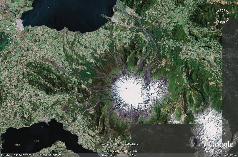
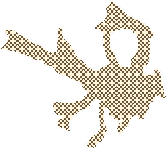
I have superimposed a zone
(brown area) on top of a satellite image of Villarrica that
represents the areas future lahars could affect. This zone is based
on the evidence of routes past lahars have taken, as well as the
major drainage basins of the volcano. As is shown in the
North-central area of the map, the tourist town Pucon, the largest
population center near the volcano, lies right in the lahar hazard
zone.⁹
Villarrica Hazard Map
***THIS HAZARD MAP IS NOT OFFICIAL!!***
Map Source: ¹¹
Other
Risks: Economic, etc.
There are a number of risks to the population surrounding Villarrica
if it does erupt soon, some of which have already been discussed.
One risk that may not seem obvious is the risk to the local economy.
As the economy around the volcano, especially the national park area
and Pucon, relies heavily on tourism, an eruption, or even a false
alarm called on the volcano, could wreak havoc on the economy. Not
only would Pucon be in great risk of impending lahars, it would also
be at risk of losing much of its revenue if tourists get scared away
or are barred from entering the city.
Hazard Threat
Assessment for Volcan Villarrica based on:
National Volcano Early Warning
System
From PDF by John Ewert, USGS Open-File Report
2005-1164.
⁶
|
Hazard and exposure factors used in threat assessment of
U.S. volcanoes for the National Volcano Early Warning
System.
See
appendix text for discussion and explanation of
abbreviations. |
|
|
Hazards Factors
|
|
Score
|
|
Volcano type
|
1 |
|
Maximum Volcano
Explosivity Index (VEI) |
2 |
|
Explosive activity
|
1 |
|
Major explosive activity
|
1 |
|
Eruption recurrence
|
4 |
|
Holocene pyroclastic
flows? |
1 |
|
Holocene lava flows?
|
1 |
|
Holocene lahars?
|
1 |
|
Holocene tsunami(s)?
|
0 |
|
Hydrothermal explosion
potential? |
1 |
|
Sector collapse
potential? |
0 |
|
Primary lahar source?
|
1 |
| |
|
|
Historical Unrest Factors
|
Score
|
Observed seismic unrest
Since
the last eruption, in the absence of eruptive activity,
within 20 km of the volcanic edifice? |
1
|
Observed ground deformation
Since
the last eruption, in the absence of eruptive activity,
inflation or other evidence of magma injection? |
0
|
Observed fumarolic or magmatic degassing
Since
the last eruption, in the absence of eruptive activity,
either heat source or magmatic gases? |
1
|
Total of Hazard Factors
|
|
Exposure Factors
|
|
|
Log10
of Volcano Population Index (VPI) at 30 km
|
4.7 |
|
Log10
of approximate population downstream or
downslope |
4.4 |
|
|
|
|
Historical evacuations? |
1 |
Local aviation exposure
|
1
|
Regional aviation exposure
|
3.25
|
Power infrastructure
|
0
|
Transportation infrastructure
|
0
|
Major development or sensitive areas
|
1
|
Volcano is a significant part of a populated island
|
0
|
Total of Exposure Factors
|
16.35
|
Sum of all hazard factors x
Sum of all exposure factors = Relative Threat Ranking
|
261.6
|
With a score of 261.6, Volcan
Villarrica is considered a HIGH RISK volcano. While this rated is
probably fairly accurate, it may be a little skewed for the
following reasons:
1). In the rating system, Villarrica received the highest score (4)
for frequency of eruptions. Villarrica also has a history for
producing large, explosive eruptions. Usually these two
characteristics do not coincide in a volcano's eruptive history; a
volcano is usually exploxive, and erupts infrequently, or it is
non-explosive and erupts frequently. To account for this anomaly,
Villarrica's potential to produce a wide range of lavas should be
considered. As mentioned in the tectonic setting, Villarrica can
produce both basaltic and andesitic lava, and therefore is capable
of producing fairly effusive eruptions as well as large eruptions.
So, Villarrica, while it does erupt often, rarely produces a large,
explosive eruption.
2). Situated in a national park, the permanent population in close
proximity to the volcano is pretty small. But, as the area has a
large tourism industry in all seasons, the local population is
greatly increased throughout the year, especially in the summer
months. I decided to use population statistics that include the
tourist population, as it is more realistic to assume that there
will probably be the average amount of tourists present when an
eruption takes place.
Given the hazard assessment data I have collected, I have a few
suggestions for mitigating risks. First, I think an acoustic
monitoring system for lahars would greater improve the safety of the
area. This monitoring system would allow local residents more time
to reach safety if a lahar was coming their way. Second, if a large
eruption does occur, I would recommend evacuating the surrounding
area (the national park, Pucon, Villarrica, countryside within 10
km).
The following is
the template that helped me come up with my hazard assessment score:
Table 2.
List
of the 15 hazard and 10 exposure factors used in the
NVEWS threat assessment and their scoring ranges.
Detailed explanation of the factors is given in Appendix
2. |
|
Hazard Factors |
Scoring Ranges |
|
Volcano type |
0 or
1 |
|
Maximum Volcanic Explosivity Index |
0 to
3 |
|
Explosive activity in past 500 years? |
0 or
1 |
|
Major explosive activity in past 5000 years?
|
0 or
1 |
|
Eruption recurrence |
0 to
4 |
|
Holocene pyroclastic flows? |
0 or
1 |
|
Holocene lahars? |
0 or
1 |
|
Holocene lava flow? |
0 or
1 |
|
Hydrothermal explosion potential? |
0 or
1 |
|
Holocene tsunami? |
0 or
1 |
|
Sector collapse potential? |
0 or
1 |
|
Primary lahar source? |
0 or
1 |
|
Observed seismic activity |
0 or
1 |
|
Observed ground deformation |
0 or
1 |
|
Observed fumarolic or magmatic degassing |
0 or
1 |
|
Total of Hazard Factors |
|
Exposure Factors |
|
Log10
of Volcano Population Index (VPI) at 30 km
|
0 to
5.4 |
|
Log10
of approximate population downstream or
downslope |
0 to
5.1 |
|
Historical fatalities? |
0 or
1 |
|
Historical evacuations? |
0 or
1 |
|
Local aviation exposure |
0 to
2 |
|
Regional aviation exposure |
0 to
5.15 |
|
Power infrastructure |
0 or
1 |
|
Transportation infrastructure |
0 or
1 |
|
Major development or sensitive areas |
0 or
1 |
|
Volcano is a significant part of a populated island
|
0 or
1 |
|
Total of Exposure Factors |
|
Sum
of all hazard factors X Sum of all exposure factors =
Relative Threat Ranking |
|
Hazard and exposure factors used in threat assessment of
U.S. volcanoes for the National Volcano Early Warning
System.
See
appendix text for discussion and explanation of
abbreviations. |
|
|
Hazards Factors
|
|
Score
|
|
Volcano type
If
volcano type is cinder cone, basaltic field, small
shield, or fissure vents: Score = 0
If
volcano type is stratocone, lava domes, complex volcano,
maar or caldera: Score = 1 |
|
|
Maximum Volcano
Explosivity Index (VEI)
If
maximum known VEI ≤ 2: Score = 0
If
maximum known VEI = 3 or 4: Score = 1
If
maximum known VEI = 5 or 6: Score = 2
If
maximum known VEI ≥ 7: Score = 3
If
no maximum VEI is listed by GVP and if volcano type = 0:
Score = 0
If
no maximum VEI is listed by GVP but volcano type = 1:
Score = 1
If
no known Holocene eruptions and the volcano is not
a silicic caldera system: Score = 0 |
|
|
Explosive activity
If
explosive activity (VEI ≥ 3) within the last 500 years:
Score = 1 |
|
|
Major explosive activity
If
major explosive activity (VEI ≥ 4) within last 5000
years: Score = 1 |
|
|
Eruption recurrence
If
eruption interval is 1-99 years: Score = 4
If
eruption interval is 100 – 1,000 years: Score = 3
If
eruption interval is 1,000 to several thousand years:
Score =2
If
eruption interval is 5,000-10,000 years, or if no
Holocene eruptions but it is a large-volume restless
silicic system that has erupted in the last 100,000
years: Score = 1
If
no known Holocene eruption: Score = 0 |
|
|
Holocene pyroclastic
flows?
If
yes: Score = 1 |
|
|
Holocene lava flows?
If
Holocene lava flows have traveled beyond the immediate
eruption site or flanks and reached populated areas:
Score =1 |
|
|
Holocene lahars?
If
Holocene lahars have traveled beyond the flanks and
reached populated areas: Score =1 |
|
|
Holocene tsunami(s)?
Has
it produced a tsunami within the Holocene? If yes: Score
= 1 |
|
|
Hydrothermal explosion
potential?
If
the volcano has had Holocene phreatic explosive
activity, and/or the volcano has thermal features that
are extensive enough to pose a potential for explosive
activity: Score =1 |
|
|
Sector collapse
potential?
If
the volcano has produced a sector collapse in
Quaternary-Holocene time and has re-built its
edifice, or, has high relief, steep flanks and
demonstrated or inferred alteration: Score = 1
|
|
|
Primary lahar source?
If
volcano has a source of permanent water/ice on edifice,
water volume > 106
m3:
Score = 1 |
|
| |
|
|
Cont’d.
Historical Unrest Factors
|
Score
|
Observed seismic unrest
Since
the last eruption, in the absence of eruptive activity,
within 20 km of the volcanic edifice? If yes: Score = 1
|
|
Observed ground
deformation
Since
the last eruption, in the absence of eruptive activity,
inflation or other evidence of magma injection? If yes:
Score = 1 |
|
Observed fumarolic or
magmatic degassing
Since
the last eruption, in the absence of eruptive activity,
either heat source or magmatic gases? If yes: Score = 1
|
|
Total of Hazard Factors
|
|
Exposure Factors
|
|
|
Log10
of Volcano Population Index (VPI) at 30 km
Calculated with LandScan population database. Visitor
statistics for volcanoes in National Parks and other
destination recreation areas are added to the VPI factor
where available. |
|
|
Log10
of approximate population downstream or
downslope
Population outside the 30 km VPI circle included within the
extent of Holocene flow deposits or reasonable inundation
modeling. This factor to be used only with volcanoes that
have a primary lahar hazard (e.g. Cascade stratovolcanoes)
or significant lava flow hazard (e.g. Mauna Loa).
|
|
|
|
|
|
Historical evacuations?
If yes,
and a permanent population is still present: Score = 1
|
|
Local aviation exposure
If any
type volcano is within 50 km of a jet-service airport, score
= 1; if a Type 1 volcano is within 300 km of a
jet-service airport, score = 1; if a Type 1 volcano
is within 300 km of a major international airport, score =
2; if none of these criteria are met, score = 0.
|
|
Regional aviation
exposure
This
score is based on the log10
of approximate daily passenger traffic in each
region. At present, in the U.S., this score ranges from 4 to
5.15. The regional risk code is applied only to type 1
volcanoes and those type 0 volcanoes that have
produced explosive eruptions. |
|
Power infrastructure
Is there
power infrastructure (e.g., power
generation/transmission/distribution for electricity, oil,
or gas) within flowage hazard zones, or in an area
frequently downwind of the volcano and close enough to
considered at some risk? If yes, score =1 |
|
Transportation
infrastructure
Is there
transportation infrastructure (e.g., port facilities, rail
lines, major roads) within flowage hazard zones, or in an
area frequently downwind of the volcano and close enough to
considered at some risk? If yes, score = 1 |
|
Major development or
sensitive areas
Are
there major developments or sensitive areas threatened
(e.g., National Park facilities, flood control projects,
government facilities, developed tourist/recreation
facilities, manufacturing or other significant economic
activity)? If yes, score =1 |
|
Volcano is a significant
part of a populated island
Holocene
volcanic deposits cover >25% of land mass. If yes, score = 1
|
|
Total of Exposure Factors
|
|
Sum of all hazard factors x
Sum of all exposure factors = Relative Threat Ranking
|
|
Source:
⁶
|