AIDS in the Circle City
Modes of Transportation
|
|
AIDS in the Circle City Modes of Transportation |
| Helpful Links
|
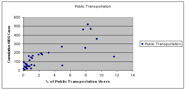
For my fourth correlation, I chose to look at the different modes of transportation people use. I assumed that the percent of people who used public transportation or walked to work would correlate positively with the cumulative AIDS cases in the respective zip codes. This proved to be a true correlation. As the scatter plot shows, the higher percent of people who used the buses to get to work, the higher the cumulative AIDS cases in a given zip code. It shows a very strong correlation. In fact, the coefficient was a whopping 0.825, much higher than the required 0.3265. The cluster at the bottom left of the graph shows all the zip codes that are on the outskirts of the city. The zip codes that prove a positive correlation are the ones that house poorer neighborhoods or the areas close to downtown, where public transportation is easily accessible. (MAP)
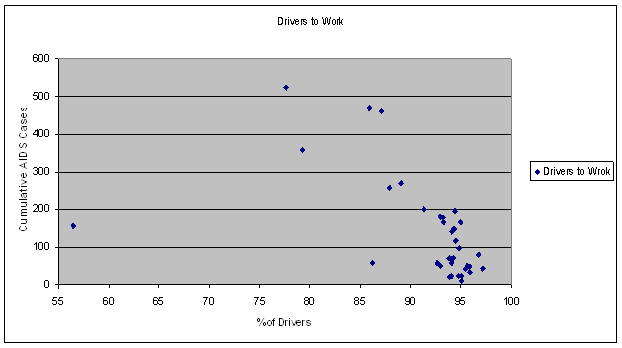
The correlation between the percent of people who drive their own cars to work and the cumulative AIDS cases was a strong negative one. A majority of drivers live outside the zip codes that are the most heavily affected with AIDS. therefore, the majority of people who drive to work will be AIDS free. The one outlying point is zip code 46204, a zip code where public transportation is heavily used. It is also one of the zip codes with the lowest median household income, which would indicate that many people are not able to own or rent their own cars. I will address the correlations between median income and AIDS cases in the next section.
Back to Travel Time to Work Next to Education Correlations
|
|
|
|
||