|

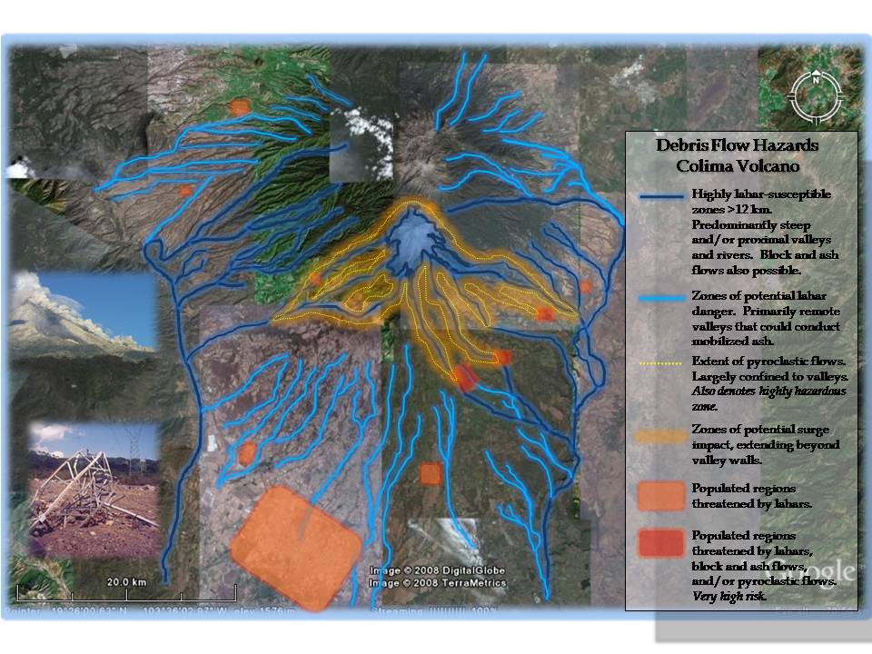
When creating
this map, I used several different sources,
including the preexisting, real hazard
map released by the Observatorio Vulcanológico18
responsible for Colima, academic articles on
Colima's behavior, and my own observations and
conclusions, especially when determining where
to place the lahar and pyroclastic flow-prone
zones, as they were recognizable on Google Earth
(as valleys). Cities were a little trickier to
locate, and some have probably inadvertently
been omitted, but the visible ones that were in
obvious proximity to danger zones have been
included, yet not identified.
Lahars –
“A general term for a volcanic debris flow or,
more generally, any rapidly flowing
water-saturated mixture of rock debris and water
from a volcano.”
11
|
How to make a lahar
-
Tephra
-
Mechanically weak rocks
-
Water source
-
Gravitational potential energy.15
|
Lahar
is a fancy, foreign term for
jokulhlaup, which is another
fancy, unpronounceable, foreign term for rocks
and ash and other volcanic material moving down
a slope or through a valley or river.
Usually "lahar" is used to refer to the wet
version of this event, and is thus commonly
known as a mudflow.
The most common method of lahar
production is rain. Lots and lots of rain.
This
can be a problem at Colima during the rainy
season from June to October, as heavy rainfall
can mobilized pyroclastic flow deposits down the
volcano slopes and into rivers and valleys,
traveling long distances, damaging
infrastructures and affecting small villages
along the banks or within valley walls.10
Lahars can also be produced by
crater lake ruptures, temporary volcanic dams,
and glacial water outburts.
10
Lahars are capable of moving swiftly, at varying
speeds depending on their sediment and clast
concentration in proportion to water, producing
consistencies that could be as liquid as water
or as thick as concrete. And not only do they
carry fine particles of ash, but huge,
meter-sized boulders may also be transported
astonishing distances.
According
to N. Davila, et al. the greatest Potential
for damage caused by this remobilization is at
San Marcos, San Antonio, La Becerrera.
10
Pyroclastic Flows/Block-and-Ash Flows
Glowing clouds, or nuees ardentes, just
seems so much more pleasant than "pyroclastic
flow" or "pyroclastic density current."
Yet there isn't anything even remotely pleasant
or romantic about a pyroclastic flow toppling
over, scorching and/or incinerating every doomed
structure, person, piece of vegetation, or
hapless head of cattle in its path.
These super-hot, super-fast flows of
super-scariness can be formed by three
mechanisms:
-
Merapi
-
Soufriere
-
Column
collapse12
And as we
all know, a picture is worth a thousand words:

Fig.
4.4 Generation of pyroclastic flows
The Basics:
This means that particularly vulnerable areas
include the ravines of Montegrande, La Lumbre,
Cordobán, and La Arena
12
-
Block-and-ash deposits at Colima have been
emplaced in drainages up to 6 kilometers
from the vent due to the collapse of
vulcanian eruptive columns, of summit domes,
and of lava flow fronts
10.
-
Pyroclastic flows typically flow less
than 5 kilometers from the crater at Colima,
but in October 2004, the longest flow
partially filled La Lumbre over 6 kilometers
10.
Areas threatened by pyroclastic flows include:
La Yerbabuena, La Becerrera, San
Antonio, El Naranjal, Atenguillo, El Fresnal,
San Marcos, Tonila, and Queseria12.

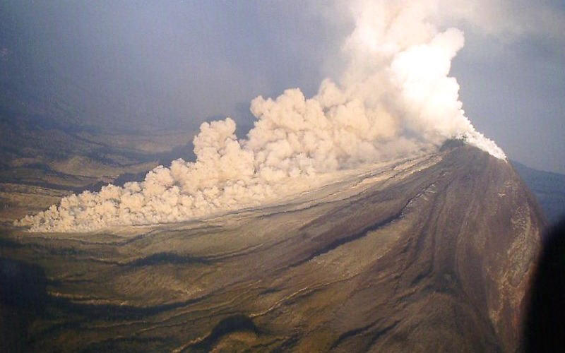
Fig
4.5 Pyroclastic flow on Colima
Side-effects
may include...
Pyroclastic Surges –
"Dilute
and turbulent clouds capable of surmounting
topographic barriers" approximately 500 meters
from parent pyroclastic flow. However,
surges resulting from flows caused by avalanches
could extend up to 1 km12.
In other
words, don't think you're safe and protected
from hazards just because you're not in a valley
or standing next to the crater.
|