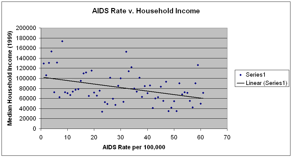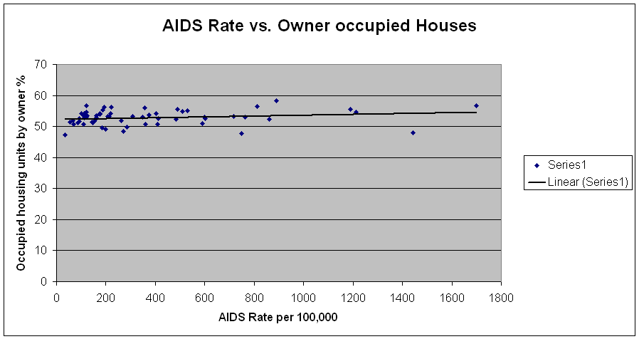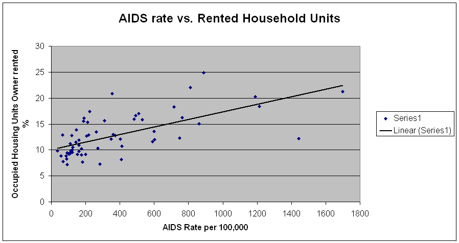
| Geography Identifier | Location Name | Rate | Households: Median household income in 1999 ; Total | Occupied housing units: Average household size; Owner occupied % | Occupied house avg size, Renter occupied % | |
| 10501 | Somers | 356 | 129692.0 | 3.35 | 89.82035928 | |
| 10502 | Ardsley | 284 | 106027.0 | 2.98 | 102.0134228 | |
| 10504 | Armonk | 153 | 130789.0 | 3.07 | 89.80263158 | |
| 10506 | Bedford | 108 | 153632.0 | 3.14 | 71.66123779 | |
| 10507 | Bedford Hills | 889 | 72568.0 | 2.98 | 82.64150943 | |
| 10510 | Briarcliff Manor | 120 | 131402.0 | 2.94 | 71.12676056 | |
| 10511 | Buchanan | 183 | 62604.0 | 2.76 | 91.76029963 | |
| 10514 | Chappaqua | 92 | 173368.0 | 3.2 | 70.92651757 | |
| 10520 | Croton-on-Hudson | 175 | 72164.0 | 2.77 | 72.72727273 | |
| 10522 | Dobbs Ferry | 188 | 70333.0 | 2.99 | 75.68627451 | |
| 10523 | Elmsford | 589 | 67100.0 | 3.13 | 85.10638298 | |
| 10528 | Harrison | 162 | 73732.0 | 2.84 | 87.07224335 | |
| 10530 | Greenburgh | 402 | 77313.0 | 2.24 | 99.10313901 | |
| 10532 | Mt.Pleasant | 143 | 78773.0 | 3.16 | 62 | |
| 10533 | Irvington | 161 | 94928.0 | 2.87 | 78.65168539 | |
| 10536 | Katonah | 85 | 109542.0 | 3.03 | 91.30434783 | |
| 10538 | Larchmont | 125 | 111492.0 | 2.98 | 69.17293233 | |
| 10543 | Mamaroneck | 160 | 64787.0 | 2.84 | 85.38461538 | |
| 10546 | New Castle | 408 | 115207.0 | 2.68 | 98.50187266 | |
| 10547 | Mohegan Lake | 199 | 71875.0 | 2.99 | 86.66666667 | |
| 10548 | Cortlandt | 270 | 65553.0 | 2.81 | 80.82706767 | |
| 10549 | Bedford corners | 261 | 75761.0 | 2.64 | 101.8726592 | |
| 10550 | Mt Vernon | 1698 | 33573.0 | 3.62 | 89.70588235 | |
| 10552 | 491 | 52593.0 | 2.59 | 85.15283843 | ||
| 10553 | 812 | 49178.0 | 3.48 | 89.8089172 | ||
| 10560 | North Salem | 121 | 101484.0 | 2.97 | 61.5658363 | |
| 10562 | Ossining | 748 | 59343.0 | 2.74 | 93.10344828 | |
| 10566 | Peekskill | 860 | 47177.0 | 2.6 | 98.03921569 | |
| 10567 | Cortlandt | 56 | 85227.0 | 3.07 | 89.47368421 | |
| 10570 | Pleasantville | 65 | 100196.0 | 2.97 | 73.11827957 | |
| 10573 | Port Chester | 361 | 53180.0 | 2.84 | 100 | |
| 10576 | Pound Ridge | 88 | 152863.0 | 2.82 | 96.08540925 | |
| 10580 | Rye | 102 | 114164.0 | 2.96 | 83.98576512 | |
| 10583 | Heathcote | 113 | 122234.0 | 2.89 | 81.78571429 | |
| 10588 | Shrub Oak | 598 | 79553.0 | 3.17 | 91.34615385 | |
| 10589 | Somers | 122 | 73472.0 | 2.19 | 83.7962963 | |
| 10590 | Lewisboro | 69 | 101226.0 | 2.87 | 78.29181495 | |
| 10591 | Tarrytown | 213 | 63219.0 | 2.58 | 98.42519685 | |
| 10594 | Mt.Pleasant | 147 | 84403.0 | 3.06 | 82.55033557 | |
| 10595 | Valhalla | 1436 | 70469.0 | 2.89 | 91.45907473 | |
| 10598 | Yorktown Heights | 112 | 85990.0 | 2.96 | 72.02797203 | |
| 10601 | White Plains | 1190 | 41201.0 | 1.85 | 104.8309179 | |
| 10603 | N White Plains | 531 | 60151.0 | 2.48 | 95.41666667 | |
| 10604 | West Harrison | 412 | 62553.0 | 2.84 | 91.28787879 | |
| 10605 | White Plains | 373 | 83587.0 | 2.57 | 93.65079365 | |
| 10606 | 483 | 55459.0 | 3.19 | 91.25874126 | ||
| 10607 | 601 | 93268.0 | 2.98 | 108.9403974 | ||
| 10701 | Yonkers | 1212 | 34821.0 | 2.85 | 98.90909091 | |
| 10703 | 510 | 41578.0 | 2.86 | 92.85714286 | ||
| 10704 | 309 | 54602.0 | 2.87 | 81.55737705 | ||
| 10705 | 716 | 35271.0 | 3.03 | 97.91666667 | ||
| 10706 | Hastings-on-Hudson | 109 | 89952.0 | 2.76 | 80.70866142 | |
| 10707 | Tuckahoe | 349 | 67929.0 | 2.7 | 87.6 | |
| 10708 | Bronxville | 192 | 72165.0 | 2.34 | 87.38738739 | |
| 10709 | Eastchester | 176 | 70888.0 | 2.69 | 74.59677419 | |
| 10710 | Yonkers | 218 | 55323.0 | 2.69 | 84.3373494 | |
| 10801 ----------- | New Rochelle | 763 | 42290.0 | 3.08 | 93.21428571 | |
| 10803 | Pelham | 206 | 90261.0 | 3.08 | 76.65505226 | |
| 10804 | New Rochelle | 92 | 126480.0 | 2.93 | 87.62886598 | |
| 10805 | 223 | 49550.0 | 2.43 | 96 | ||
| 10918 | Chester | 35 | 71016.0 | 3.07 | 77.08333333 | |
| correlation | -0.558 | 0.051161081 | 0.465149181 |


