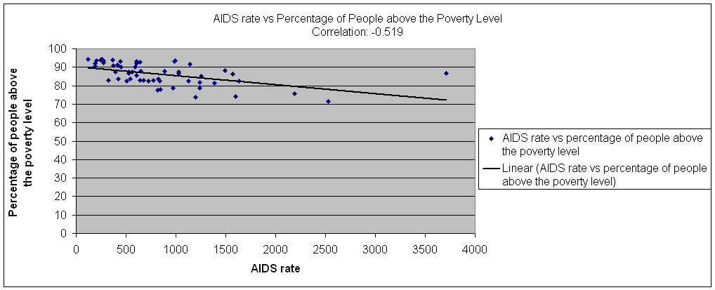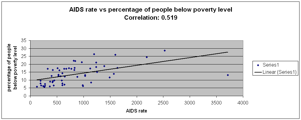
Table F: Correlation between AIDS rate and Poverty Level
| Zipcode | Total Pop. | AIDSrate | Population for whom poverty status is determined: Total | Population for whom poverty status is determined: Income in 1999 below poverty level | %below poverty level | Population for whom poverty status is determined: Income in 1999 at or above poverty level | %above poverty level |
| 11004 Glen Oaks | 14682 | 122.6 | 14507 | 846 | 5.831667 | 13661 | 94.16833 |
| 11005 Floral Park | 2195 | * | 2234 | 105 | 4.70009 | 2129 | 95.29991 |
| 11101 Long Island City | 25595 | 2527.8 | 24905 | 7142 | 28.67697 | 17763 | 71.32303 |
| 11102 Astoria | 36291 | 969.9 | 35971 | 7629 | 21.20875 | 28342 | 78.79125 |
| 11103 Astoria | 44321 | 638.5 | 43647 | 7453 | 17.07563 | 36194 | 82.92437 |
| 11104 Sunnyside | 29506 | 772.7 | 29413 | 5020 | 17.06728 | 24393 | 82.93272 |
| 11105 Astoria | 42117 | 543.7 | 41931 | 6785 | 16.18135 | 35146 | 83.81865 |
| 11106 Astoria | 43130 | 846.3 | 43171 | 9483 | 21.96613 | 33688 | 78.03387 |
| 11354 Flushing | 54329 | 423.3 | 52526 | 8603 | 16.37856 | 43923 | 83.62144 |
| 11355 Flushing | 83281 | 510.3 | 82748 | 14532 | 17.56175 | 68216 | 82.43825 |
| 11356 College Point | 20444 | 420.7 | 20244 | 1878 | 9.276823 | 18366 | 90.72318 |
| 11357 Whitestone | 39491 | 276 | 39279 | 2549 | 6.489473 | 36730 | 93.51053 |
| 11358 Flushing | 38647 | 191.5 | 38051 | 3638 | 9.560853 | 34413 | 90.43915 |
| 11360 Bayside | 19350 | 263.6 | 19144 | 1093 | 5.709361 | 18051 | 94.29064 |
| 11361 Bayside | 29206 | 277.3 | 28912 | 2168 | 7.498616 | 26744 | 92.50138 |
| 11362 Little Neck | 17502 | 188.5 | 17381 | 1388 | 7.985732 | 15993 | 92.01427 |
| 11363 Little Neck | 6917 | * | 6867 | 211 | 3.072666 | 6656 | 96.92733 |
| 11364 Oakland Gardens | 34539 | 243.2 | 34542 | 2117 | 6.128771 | 32425 | 93.87123 |
| 11365 Fresh Meadows | 41566 | 370.5 | 41773 | 3780 | 9.048907 | 37993 | 90.95109 |
| 11366 Fresh Meadows | 13366 | 366.6 | 13346 | 798 | 5.97932 | 12548 | 94.02068 |
| 11367 Flushing | 38216 | 397.7 | 38156 | 4793 | 12.56159 | 33363 | 87.43841 |
| 11368 Corona | 98841 | 816.5 | 97519 | 21692 | 22.24387 | 75827 | 77.75613 |
| 11369 East Elmhurst | 36110 | 1127.1 | 35672 | 6207 | 17.4002 | 29465 | 82.5998 |
| 11370 East Elmhurst | 43142 | 3713.3 | 29613 | 3891 | 13.1395 | 25722 | 86.8605 |
| 11372 Jackson Heights | 71308 | 1386.9 | 70874 | 13293 | 18.75582 | 57581 | 81.24418 |
| 11373 Elmhurst | 105723 | 835.2 | 105462 | 18585 | 17.62246 | 86877 | 82.37754 |
| 11374 Rego Park | 44189 | 529.5 | 43178 | 5750 | 13.31697 | 37428 | 86.68303 |
| 11375 Forest Hills | 70204 | 450.1 | 70177 | 6927 | 9.870755 | 63250 | 90.12924 |
| 11377 Woodside | 88339 | 324.8 | 87937 | 15006 | 17.06449 | 72931 | 82.93551 |
| 11378 Maspeth | 34053 | 590.3 | 33625 | 3270 | 9.724907 | 30355 | 90.27509 |
| 11379 Middle Village | 28984 | 414 | 28430 | 2453 | 8.62821 | 25977 | 91.37179 |
| 11385 Ridgewood | 97524 | 677.8 | 97456 | 16651 | 17.08566 | 80805 | 82.91434 |
| 11411 Cambria Heights | 21282 | 991.4 | 21243 | 1333 | 6.275008 | 19910 | 93.72499 |
| 11412 Saint Albans | 37452 | 1492.6 | 36963 | 4341 | 11.74418 | 32622 | 88.25582 |
| 11413 Springfield Gardens | 39827 | 984.3 | 40246 | 2756 | 6.847886 | 37490 | 93.15211 |
| 11414 Howard Beach | 28121 | 441 | 27978 | 1866 | 6.669526 | 26112 | 93.33047 |
| 11415 Kew Gardens | 20956 | 1030.7 | 20459 | 2704 | 13.21668 | 17755 | 86.78332 |
| 11416 Ozone Park | 23668 | 726.7 | 23823 | 4158 | 17.45372 | 19665 | 82.54628 |
| 11417 Ozone Park | 28607 | 566.3 | 28202 | 3520 | 12.48138 | 24682 | 87.51862 |
| 11418 Richmond Hill | 36571 | 825.8 | 36421 | 5970 | 16.39164 | 30451 | 83.60836 |
| 11419 South Richmond Hill | 48867 | 603.7 | 48629 | 6978 | 14.34946 | 41651 | 85.65054 |
| 11420 South Ozone Park | 45498 | 885.8 | 45273 | 5478 | 12.09993 | 39795 | 87.90007 |
| 11421 Woodhaven | 37664 | 647.8 | 37467 | 4566 | 12.18672 | 32901 | 87.81328 |
| 11422 Rosedale | 30449 | 640.4 | 30116 | 2172 | 7.212113 | 27944 | 92.78789 |
| 11423 Hollis | 31240 | 1030.7 | 30565 | 3877 | 12.68444 | 26688 | 87.31556 |
| 11426 Bellerose | 18727 | 202.9 | 17864 | 1172 | 6.560681 | 16692 | 93.43932 |
| 11427 Queens Village | 23014 | 604 | 23084 | 1580 | 6.844568 | 21504 | 93.15543 |
| 11428 Queens Village | 21023 | 604.1 | 20960 | 1675 | 7.991412 | 19285 | 92.00859 |
| 11429 Queens Village | 27647 | 1139.4 | 26722 | 2250 | 8.420028 | 24472 | 91.57997 |
| 11430 Jamaica | 229 | * | 159 | 68 | 42.7673 | 91 | 57.2327 |
| 11432 Jamaica | 57045 | 1256.9 | 54181 | 8114 | 14.97573 | 46067 | 85.02427 |
| 11433 Jamaica | 28435 | 2191 | 28365 | 6946 | 24.48793 | 21419 | 75.51207 |
| 11434 Jamaica | 59142 | 1567.4 | 57992 | 8046 | 13.87433 | 49946 | 86.12567 |
| 11435 Jamaica | 53877 | 1236.1 | 53252 | 9679 | 18.17584 | 43573 | 81.82416 |
| 11436 Jamaica | 18148 | 1636.5 | 17607 | 3110 | 17.66343 | 14497 | 82.33657 |
| 11691 Far Rockaway | 56184 | 1196.1 | 53242 | 14032 | 26.35513 | 39210 | 73.64487 |
| 11692 Arverne | 15893 | 1598.2 | 15111 | 3926 | 25.98107 | 11185 | 74.01893 |
| 11693 Far Rockaway | 11157 | 1236.9 | 11287 | 2383 | 21.11278 | 8904 | 78.88722 |
| 11694 Rockaway Park | 19278 | 529.1 | 18360 | 2300 | 12.52723 | 16060 | 87.47277 |
| 11697 Breezy Point | 4226 | * | 4337 | 233 | 5.372377 | 4104 | 94.62762 |
| 0.519363 | -0.51936 |