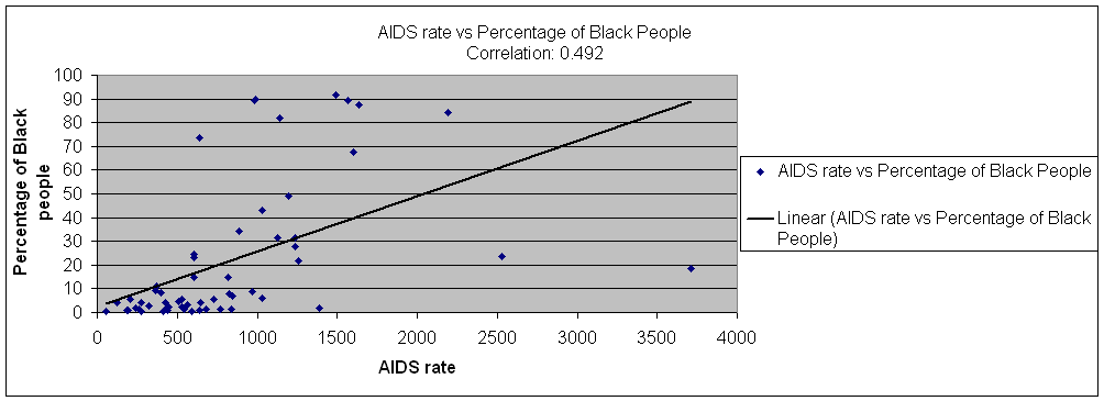
Table B: Correlation between AIDS rate and percentage for Black Race
| Zipcode | Total Pop. | AIDSrate | BlackPop. | %BlackPeople |
| 11004 Glen Oaks | 14682 | 122.6 | 597 | 4.066204 |
| 11005 Floral Park | 2195 | * | 25 | 1.138952 |
| 11101 Long Island City | 25595 | 2527.8 | 6067 | 23.70385 |
| 11102 Astoria | 36291 | 969.9 | 3174 | 8.74597 |
| 11103 Astoria | 44321 | 638.5 | 431 | 0.972451 |
| 11104 Sunnyside | 29506 | 772.7 | 391 | 1.325154 |
| 11105 Astoria | 42117 | 543.7 | 639 | 1.517202 |
| 11106 Astoria | 43130 | 846.3 | 3029 | 7.022954 |
| 11354 Flushing | 54329 | 423.3 | 2177 | 4.007068 |
| 11355 Flushing | 83281 | 510.3 | 3866 | 4.642115 |
| 11356 College Point | 20444 | 420.7 | 195 | 0.953825 |
| 11357 Whitestone | 39491 | 276 | 130 | 0.329189 |
| 11358 Flushing | 38647 | 191.5 | 337 | 0.871995 |
| 11360 Bayside | 19350 | 263.6 | 239 | 1.235142 |
| 11361 Bayside | 29206 | 277.3 | 1250 | 4.279942 |
| 11362 Little Neck | 17502 | 188.5 | 168 | 0.95989 |
| 11363 Little Neck | 6917 | * | 27 | 0.390343 |
| 11364 Oakland Gardens | 34539 | 243.2 | 608 | 1.760329 |
| 11365 Fresh Meadows | 41566 | 370.5 | 4541 | 10.92479 |
| 11366 Fresh Meadows | 13366 | 366.6 | 1234 | 9.232381 |
| 11367 Flushing | 38216 | 397.7 | 3141 | 8.219071 |
| 11368 Corona | 98841 | 816.5 | 14727 | 14.89969 |
| 11369 East Elmhurst | 36110 | 1127.1 | 11378 | 31.50928 |
| 11370 East Elmhurst | 43142 | 3713.3 | 8027 | 18.606 |
| 11372 Jackson Heights | 71308 | 1386.9 | 1423 | 1.995569 |
| 11373 Elmhurst | 105723 | 835.2 | 1456 | 1.377184 |
| 11374 Rego Park | 44189 | 529.5 | 1032 | 2.335423 |
| 11375 Forest Hills | 70204 | 450.1 | 1572 | 2.239189 |
| 11377 Woodside | 88339 | 324.8 | 2289 | 2.591155 |
| 11378 Maspeth | 34053 | 590.3 | 175 | 0.513905 |
| 11379 Middle Village | 28984 | 414 | 171 | 0.589981 |
| 11385 Ridgewood | 97524 | 677.8 | 1294 | 1.326853 |
| 11411 Cambria Heights | 21282 | 991.4 | 19097 | 89.73311 |
| 11412 Saint Albans | 37452 | 1492.6 | 34364 | 91.75478 |
| 11413 Springfield Gardens | 39827 | 984.3 | 35608 | 89.40668 |
| 11414 Howard Beach | 28121 | 441 | 264 | 0.9388 |
| 11415 Kew Gardens | 20956 | 1030.7 | 1307 | 6.236877 |
| 11416 Ozone Park | 23668 | 726.7 | 1364 | 5.763056 |
| 11417 Ozone Park | 28607 | 566.3 | 974 | 3.404761 |
| 11418 Richmond Hill | 36571 | 825.8 | 2813 | 7.691887 |
| 11419 South Richmond Hill | 48867 | 603.7 | 7163 | 14.65815 |
| 11420 South Ozone Park | 45498 | 885.8 | 15512 | 34.09381 |
| 11421 Woodhaven | 37664 | 647.8 | 1488 | 3.950722 |
| 11422 Rosedale | 30449 | 640.4 | 22366 | 73.45397 |
| 11423 Hollis | 31240 | 1030.7 | 13394 | 42.87452 |
| 11426 Bellerose | 18727 | 202.9 | 1006 | 5.371923 |
| 11427 Queens Village | 23014 | 604 | 5372 | 23.34231 |
| 11428 Queens Village | 21023 | 604.1 | 5116 | 24.33525 |
| 11429 Queens Village | 27647 | 1139.4 | 22718 | 82.17166 |
| 11430 Jamaica | 229 | * | 117 | 51.0917 |
| 11432 Jamaica | 57045 | 1256.9 | 12370 | 21.68463 |
| 11433 Jamaica | 28435 | 2191 | 23936 | 84.17795 |
| 11434 Jamaica | 59142 | 1567.4 | 52918 | 89.47618 |
| 11435 Jamaica | 53877 | 1236.1 | 16914 | 31.39373 |
| 11436 Jamaica | 18148 | 1636.5 | 15868 | 87.43663 |
| 11691 Far Rockaway | 56184 | 1196.1 | 27681 | 49.26848 |
| 11692 Arverne | 15893 | 1598.2 | 10765 | 67.73422 |
| 11693 Far Rockaway | 11157 | 1236.9 | 3117 | 27.93762 |
| 11694 Rockaway Park | 19278 | 529.1 | 1109 | 5.752671 |
| 11697 Breezy Point | 4226 | * | 5 | 0.118315 |
| Correlation Coefficient for AIDS rate and Percentage Black Race | 0.492177 |
